IncidentResponse.us

IncidentResponse.usIncidentResponse.usIncidentResponse.us

IncidentResponse.us

IncidentResponse.usIncidentResponse.usIncidentResponse.us
  • Home
  • Forensic Services
    • Cell & Mobile Devices
    • Computers
    • Call Detail Records
    • Google Location History
    • GPS Mapping
    • Cell Site Propagation
    • Security DVR Recovery
    • Drones
  • Koeberlein
    • Background
    • Degrees & Certifications
    • Organizations
    • Training & Seminars
    • Awards
    • Curriculum Vitae
  • About Us
    • Pricing
    • Blog
    • Contact Us
  • Login
  • More
    • Home
    • Forensic Services
      • Cell & Mobile Devices
      • Computers
      • Call Detail Records
      • Google Location History
      • GPS Mapping
      • Cell Site Propagation
      • Security DVR Recovery
      • Drones
    • Koeberlein
      • Background
      • Degrees & Certifications
      • Organizations
      • Training & Seminars
      • Awards
      • Curriculum Vitae
    • About Us
      • Pricing
      • Blog
      • Contact Us
    • Login
  • Sign In

  • My Account
  • Signed in as:

  • filler@godaddy.com


  • My Account
  • Sign out

Signed in as:

filler@godaddy.com

  • Home
  • Forensic Services
    • Cell & Mobile Devices
    • Computers
    • Call Detail Records
    • Google Location History
    • GPS Mapping
    • Cell Site Propagation
    • Security DVR Recovery
    • Drones
  • Koeberlein
    • Background
    • Degrees & Certifications
    • Organizations
    • Training & Seminars
    • Awards
    • Curriculum Vitae
  • About Us
    • Pricing
    • Blog
    • Contact Us
  • Login

Account


  • My Account
  • Sign out


  • Sign In
  • My Account

GPS Mapping

How GPS Works (Short Version)

GPS is a constellation of 24 or more satellites flying 20,350 km above the surface of the Earth.  Each one circles the planet twice a day in one of six orbits to provide continuous, worldwide coverage.


1.  GPS satellites broadcast radio signals providing their locations, status, and precise time (t1) from on-board atomic clocks.


2.  The GPS radio signals travel through space at the speed of light (c), more than 299,792 km/second.


3.  A GPS device receives the radio signals, noting their exact time of arrival (t2), and uses these to calculate its distance from each satellite in view.


To calculate its distance from a satellite, a GPS device applies this formula to the satellite's signal: distance = rate x time, where rate is (c) and time is how long the signal traveled through space.


The signal's travel time is the difference between the time broadcast by the satellite (t1) and the time the signal is received (t2).

The GPS signals travel by line of sight, meaning they will pass through clouds, glass and plastic but will not go through most solid objects, such as buildings and mountains. However, modern receivers are more sensitive and can usually track through houses.


A GPS signal contains 3 different types of information:


  • Pseudorandom code is an I.D. code that identifies which satellite is transmitting information. You can see which satellites you are getting signals from on your device's satellite page. 


  • Ephemeris data is needed to determine a satellite's position and gives important information about the health of a satellite, current date and time.


  • Almanac data tells the GPS receiver where each GPS satellite should be at any time throughout the day and shows the orbital information for that satellite and every other satellite in the system.

GPS Signal Errors Sources

A number of conditions can reduce the accuracy of a GPS receiver. From a top-down perspective (from orbit down to ground level), the possible sources of trouble look like this:


  • Ephemeris errors: Ephemeris errors occur when the satellite doesn’t correctly transmit its exact position in orbit.
  • Ionosphere conditions: The ionosphere starts at about 43–50 miles above the Earth and continues for hundreds of miles. Satellite signals traveling through the ionosphere are slowed down because of plasma (a low density gas). Although GPS receivers attempt account for this delay, unexpected plasma activity can cause calculation errors.
  • Troposphere conditions: The troposphere is the lowest region in the Earth’s atmosphere and goes from ground level up to about 11 miles. Variations in temperature, pressure, and humidity all can cause variations in how fast radio waves travel, resulting in relatively small accuracy errors.


  • Timing errors: Because placing an atomic clock in every GPS receiver is impractical, timing errors from the receiver’s less-precise clock can cause slight position inaccuracies.
  • Multipath errors: When a satellite signal bounces off a hard surface (such as a building or canyon wall) before it reaches the receiver, a delay in the travel time occurs, which causes an inaccurate distance calculation.
  • Poor satellite coverage: When a significant part of the sky is blocked, your GPS unit has difficulty receiving satellite data. Unfortunately, you can’t say that if 50 percent (or some other percentage) of the sky is blocked, you’ll have poor satellite reception; this is because the GPS satellites are constantly moving in orbit. A satellite that provides a good signal one day may provide a poor signal at the exact same location on another day because its position has changed and is now being blocked by a tree. The more open sky you have, the better your chances of not having satellite signals blocked. Building interiors, streets surrounded by tall buildings, dense tree canopies, canyons, and mountainous areas are typical problem areas.

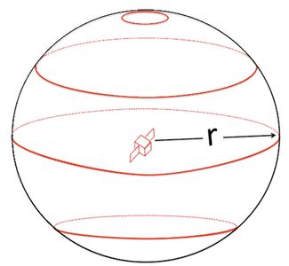
Each satellite sends out a signal that includes its own position and the time. The receiver can calculate the time it took the signal to travel and multiply that by the speed of the signal (the speed of light) to compute the distance. That distance ("r" in the figure) defines a sphere. The receiver could be at any point on that sphere. On the diagram it is more than just the black line, it is the entire outer shell of the sphere. (Remember: three dimensions.) 

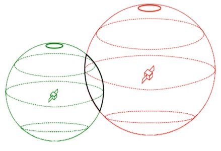
With two satellites you have an intersection of two spheres and the receiver could be in any position along those intersecting spheres. Once again, it is more than just the black lines in the diagram, your position could be at any point inside the three-dimensional shape described by the black line. 

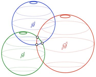
With three satellites you narrow the possible location down to one of three points (the three black points). 

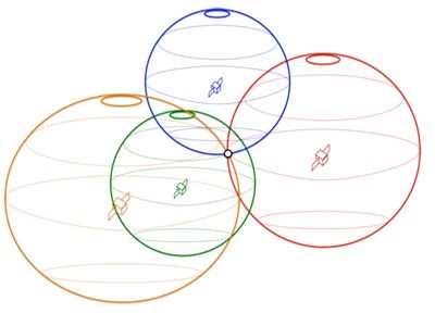
 With one more satellite, you have narrowed the universe of possible intersections to just one (the single black point). 

GPS Accuracy: HDOP, PDOP, GDOP, Multipath & the Atmosphere

Have you ever wondered about your GPS accuracy?


A well-designed GPS receiver can achieve a horizontal accuracy of 3 meters or better and vertical accuracy of 5 meters or better 95% of the time. Augmented GPS systems can provide sub-meter accuracy.

But it’s still not perfect.

Geometric/Position Dilution of Precision

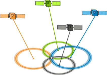
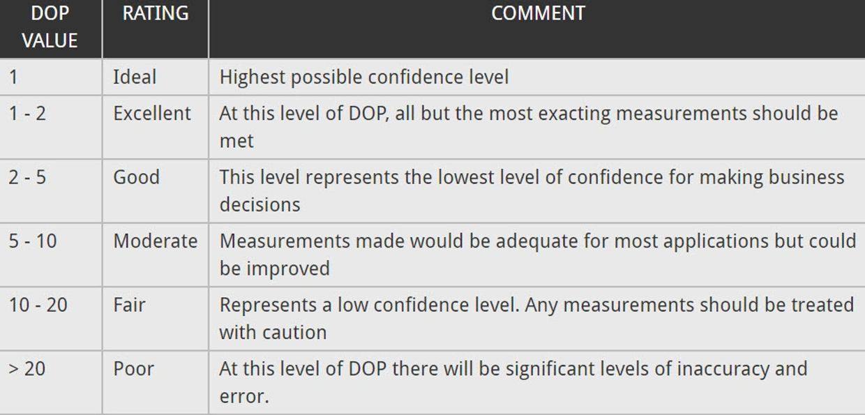
GDOP (geometric dilution of precision) or PDOP (position dilution of precision) describes error caused by the relative position of the GPS satellites. Basically, the more signals a GPS receiver can “see” (spread apart versus close together), the more precise it can be.

From the observer’s point of view, if the satellites are spread apart in the sky, then the GPS receiver has a good GDOP.

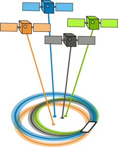
But if the satellites are physically close together, then you have poor GDOP. This lowers the quality of your GPS positioning potentially by meters .

Atmosphere Refraction

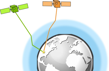
The troposphere and ionosphere can change the speed of propagation of a GPS signal. Due to atmospheric conditions, the atmosphere refracts the satellite signals as they pass through on their way to the earth’s surface.

In order to fix this, a GPS can use two separate frequencies to minimize propagation speed error. Depending on conditions, this type of GPS error could offset position anywhere from 5 meters

Multipath Effects

 One possible error source in GPS calculations is the multipath effect. Multipath occurs when the GPS satellite signal bounces off of nearby structures like buildings and mountains.


In effect, your GPS receiver detects the same signal twice at different ranges. However, this error is a bit less concerning and could cause anywhere from 1 meter of position error.

Satellite Time and Location (Ephemeris)

 The accuracy of a GPS satellite’s atomic clock is one nanosecond for each clock tick. That’s pretty impressive stuff.


Using trilateration of time signals in orbit, GPS receivers on the ground can obtain accurate positions. But due to the inaccuracy of satellite’s atomic clock being synchronized, this can offset a position measurement by 2 meters or so.


The ephemeris information contains details about that specific satellite’s location. But if you don’t know their exact location at a particular time, this can be a source of error.

Copyright © 2020 IncidentResponse.us - All Rights Reserved.

a Digital Forensics Center of Excellence